


 6 / 32

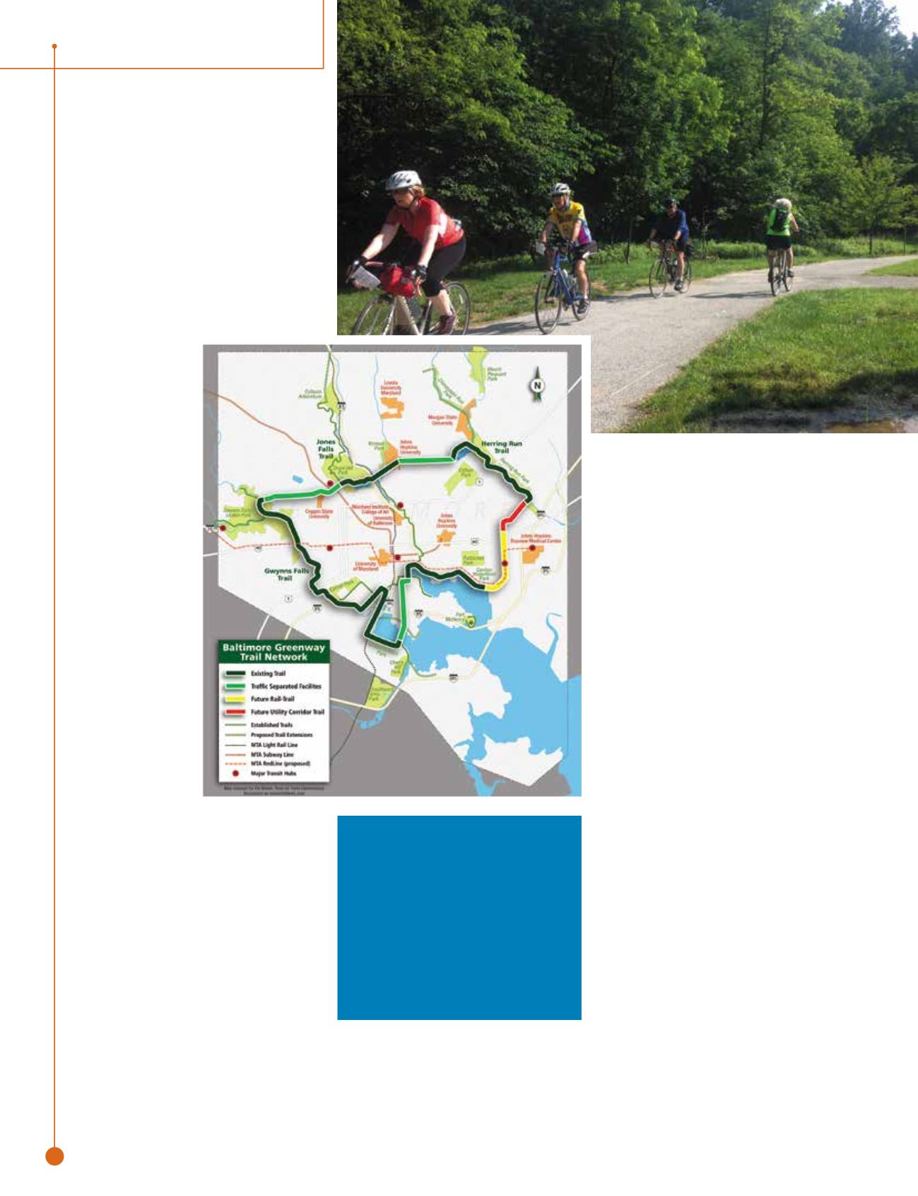
Trail network under construction:
Baltimore Greenway Trails Network
Location:
Baltimore, Maryland
Used railroad corridor:
Multiple,
including the Maryland and
Pennsylvania Railroad and possibly
Norfolk Southern
Length:
Approximately 30 miles
Surface:
Gravel and paved
EYE ON:
Baltimore’s Greenway
Trails Network
By Katie Harris
Frederick Law Olmsted Jr. painted a
visionary picture for Baltimore in his
comprehensive
1904 Report Upon the
Development of Public Grounds for Greater
Baltimore
. His
blueprints for
Baltimore’s park
system, which
focused attention
on the three stream
valleys (Gwynns
Falls, Jones Falls
and Herring Run)
and other natural
features unique
to the city, are a
shining example
of successful urban
planning. More
than a century
later, these stream
valleys, including
trails that paral-
lel the waterways,
are cherished by
Baltimore residents
and remain among
the city’s greatest
assets. And now,
they are also pieces
of a new vision
for a connected
Baltimore.
In 2015, Rails-to-Trails Conservancy
(RTC) formed the Baltimore Greenway
Trails Network Coalition, bringing public
agencies, nonprofit organizations, private
firms and public health agencies together
to help connect Baltimore’s existing trails
and create new safe avenues for non-
motorized travel around the city. When
complete, the network will encompass
30 miles of bike and pedestrian-friendly
routes that weave through the stream val-
leys and along Baltimore’s popular water-
front, the Inner Harbor.
Currently, the trails in this network
are not connected. “Our goal is to take
trails and pathways that stretch between
Baltimore’s open spaces and attach them
by completing gaps and taking advantage
of existing infrastructure,” says Jim Brown,
RTC’s trail development manager and
lead organizer for the Baltimore Greenway
Trails Network Coalition. The result will
be a seamless system of pathways unim-
peded by barriers such as highways and
thoroughfares that present safety issues for
bikers and walkers and cause obstructions,
both real and perceived, to links between
city neighborhoods.
The coalition hopes the greenway proj-
ect can help reverse the urban fragmenta-
tion found in older portions of the city.
“This trail network is a really equitable way
to break down [the] physical and cultural
barriers,” Brown says.
The western side of the trail network
is composed of the Gwynns Falls Trail,
which extends from Gwynns Falls/Leakin
Park south to Middle Branch Park. From
Leakin Park in the west to Druid Hill
Park—northeast of the Mondawmin
neighborhoods—in the east, the auto-
centric Gwynns Falls Parkway will be the
main connector. Traffic-separated facilities
will be built so that walkers and bikers can
navigate the east-west connection without
having to rely on a car.
“Connecting the greater Mondawmin
neighborhoods between Leakin and Druid
Hill parks so that residents have bet-
ter access means a lot to me personally,
because these are neighborhoods that have
historically been underinvested in,” says Liz
Cornish, executive director of Bikemore
( bikemore.net ), Baltimore’s bicycle advo-
cacy organization. “They are some of our
Gwynns Falls Trail in
Baltimore, Maryland, part
of the city’s developing
greenway network
DESIGN BY DANIELLE MARKS AND RTC/JIM BROWN
rails
to
trails
u
spring/summer.16
4
tracks ’n’ ties