Basic HTML Version


rails
to
trails
u
fall.12
10
Each bend along the riparian pathway
yields surprises. A fox might dart out
from the underbrush. Look closely at the
riverbank and you might spot a mink
popping its head up over a rock, inquisi-
tively checking you out. Mule deer often
cross the Greenbelt, heading down to the
river for a drink or to browse in the cot-
tonwood thickets. One morning I was
greeted by a great blue heron wading in
the river, fishing for its next meal.
Ask any of the almost 90 percent of
Boiseans who use the Greenbelt what
they like about it, and you’ll find that
wildlife watching is high on the list. “The
wildlife viewing there is incredible, espe-
cially for birds,” says Bob Young, a hiker
and avid birdwatcher. Experiencing the
trail, he says, is “one way to enjoy the
outdoors and the ‘Idaho wilds’ without
leaving Boise.”
The Boise River Greenbelt gets top
billing from residents of outlying towns,
too. Visitors from Meridian, Nampa and
Kuna, 10 to 20 miles away, regularly
travel to Boise to ride or walk the trail.
It’s a wildlife-watching path, a recreation
corridor and a history lesson, but it is also
quickly turning into a major transporta-
tion route. That’s because the Greenbelt is
the main artery of an area-wide trail sys-
tem that connects Boise to its parks and
neighboring towns.
“I’ve been around the country and
looked at a lot of trails,” says Jim Hall,
who recently retired as director of Boise
Parks & Recreation. “Although each one
is unique, the Boise River Greenbelt has
all the components for making a great
trail system.”
For one thing, it has a river, he says.
What’s more, the trail doesn’t cross
streets, it’s all in one segment, and it runs
by restaurants and other businesses. If
you’re out bicycling, you can stop for a
microbrew and burger here, a pizza over
there or seafood in another place. The res-
taurants offer outside patio dining where
you can watch the river go by and look at
its beautiful banks.
Built on History
In the last four decades, the Greenbelt has
grown from a quarter mile to more than
22 miles, including paths on both sides of
the river. It’s built on Idaho history. Take a
ride on the easternmost sections, and you
can see parts of the Oregon Trail coming
off the desert rim rock. Pioneer missionar-
ies passed through here as early as 1836.
The Greenbelt’s foundation in this
eastern section was laid as a railbed in the
early 1900s as railroads extended across
the state, carrying Idaho’s timber and min-
erals to other regions. Between 1904 and
1906, Barber Dam was built on the Boise
River to capture logs for the Barber Mill
in log drives from the mountains north
and east of Boise. The log drives didn’t pan
out because silt formed behind the dam,
so timber interests decided to build a rail-
road from Boise up to the Idaho City area,
about 37 miles to the northeast, to haul
the logs. You can learn all this and more
from signs along the Greenbelt.
The Intermountain Railway started
shipping logs to Barber Mill in 1914,
but the railroad closed in 1934 after the
Depression hit the lumber business. From
1910 to 1915 the U.S. Reclamation
Service (now the U.S. Bureau of
Reclamation) built another track northeast
of Boise to convey workers and equipment
for construction of Arrowrock Dam.
Railbeds for interurban trolleys haul-
ing goods and passengers came off the
high-lying Boise Bench and from west
of Boise across the city, past the old
Idaho Territorial Prison (now the Old
Idaho Penitentiary State Historic Site),
and extending to the mill community of
Barber. The interurbans also connected
with the Union Pacific and Oregon Short
Line railroads, which were prominent in
PREVIOUS PAGE, FISHING LURE: PETR MALYSHEY/VEER
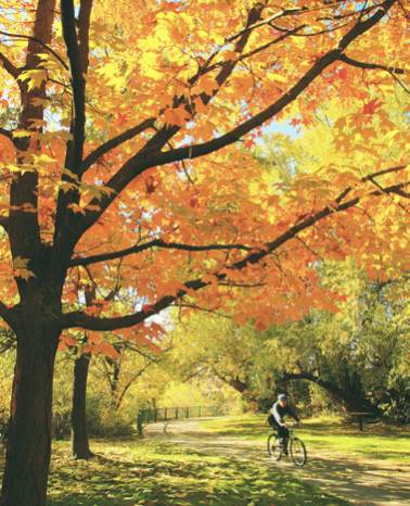
Thanks to a city ordinance requiring all
development to be set back a minimum of 70
feet from the river, the Greenbelt treats visitors
to a park-like setting at nearly every turn.