Basic HTML Version


184
84
84
boiseriver
diversion
dam
boise state
university
old idahopenitentiary
statehistoric site
boise
airport
44
44
21
21
Map for reference only.
Not for navigation.
miles
0
1
2
Ann
Morrison
Park
Julia Davis
Park
Municipal
Park
Warm
Springs
Park
Warm Springs
Golf Course
Barber
Park
Baggley
Park
lucky peak
state recreationarea
lucky peak
state park
Kathrynn
Albertson
Park
Veterans
Memorial Park
B. Quinn
Riverside
Park
River
Pointe
Park
willowlane
athleticcomplex
20
20
26
26
Parking
Boise River
Greenbelt
Trail endpoint
Restrooms
Total trail length:
22 miles
Trail surface:
Asphalt
Crushed stone
map illustration by
daniellemarks.com
Silver
Lake
B
o
i
s
e
R
i
v
e
r
L
u
c
k
y
P
e
a
k
L
a
k
e
B O I
S E
River Beach
Ln.
Marigold St.
Garrett St.
Chinden Blvd.
Veterans Pkwy.
Emerald St.
Americana
Blvd.
Bown
Rd.
Boise Ave.
Amity Rd.
Vista Ave.
9th St.
Curtis Rd.
Orchard St.
W. State St.
W. State St.
Fort St.
W. Hill Rd.
16th St.
Main St.
E
.
W
a
r
m
S
p
r
i
n
g
s
A
v
e
.
W
a
r
m
S
p
r
i
n
g
s
A
v
e
.
P
a
r
k
c
e
n
t
e
r
B
l
v
d
.
G
o
w
e
n
R
d
.
S
.
F
e
d
e
r
a
l
W
a
y
E
c
k
e
r
t
R
d
.
S
.
S
u
r
p
r
i
s
e
W
a
y
I DAHO
11
rails
to
trails
u
fall.12
southern Idaho and ran between Oregon
and Utah. In fact, during the Jazz Age,
Boise was a popular and convenient
rail stop for musicians on concert tours
going from Ogden or Salt Lake City to
Portland.
The old Boise River railroad bridge
near Fairview Avenue and Main Street,
built in 1923, is another railroad legacy.
I enjoy crossing it on my commutes,
and my grandkids are fascinated just
walking across the bridge. It’s a great
bird-watching and fish-watching spot.
On a warm spring afternoon, look down
from the bridge and you’ll see rainbow
trout surfacing in the river for midges.
Kingfishers and mergansers put on a
show as they dive for
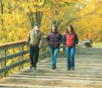
the fish. Many anglers
bike the trail to the river
to fish—including kids
who want to bicycle to
a fishing hole from their
neighborhoods.
Fishing can be quite
good in the Boise River
and also in the ponds
along the pathway. The
Idaho Department
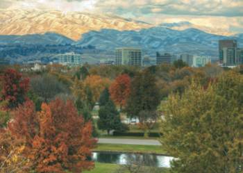
The Boise skyline and
foothills of the Rocky
Mountains; at right, the
Greenbelt near the 36th
Street Footbridge.
BACKGROUND: IRENA JANCAUSKIENE/VEER