SEO Version


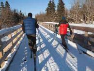
rails
to
trails
u
winter.12
13
Country Store in Columbia Falls, 41
miles into the trail, a group of locals
surrounds me, shocked. “I can’t believe
you’re walking that old rail line,” says one.
“You’d ft right in around here, ’cause it
looks like you ain’t that smart.” Te thick
Down East accent makes it sound like
“smaahart,” and we share a chuckle.
Te day warms, and I hear water rush-
ing through culverts under the trail. At
the Columbia Falls headquarters of the
Downeast Salmon Federation, Executive
Director Dwayne Shaw tells me those
gurgling culverts aren’t carrying just
drainage from the trail. Tey are ancient
streams concealing a hidden treasure.
“Many of those streams are the spawn-
ing grounds for the endangered Atlantic
salmon,” he says. “Tey’re the last stand
for those fsh.”
For more than 20 years, this small
group has worked to conserve endangered
salmon and their habitat; they hope the
Sunrise Trail will bring awareness to the
cause. Jacob van de Sande, the federa-
tion’s education and hatchery manager,
explains the connection between fsh and
trail. “Outdoor activities lead to appre-
ciation and conservation of our natural
world,” he says. “Te more time you
spend outside, the more you want to take
care of every resource!”
Shaw and van de Sande’s infectious
optimism transforms my trail experience:
I’m not only appreciating the crystalline
beauty of the visible; I now am acutely
conscious of all the precious, hidden
natural resources the Sunrise Trail helps
protect.
At the 54-mile point, the trail plows
through Machias, where I pause for cof-
fee and pie at Helen’s Restaurant. Te
blueberry pie richly deserves its 2005
LIFE Magazine
recognition as the “Best
Blueberry Pie in America.” As I head
back to the pathway, sun glints of the
frozen glory of Machias Bay with such
intensity, I’m forced to squint behind
my sunglasses.
As I move on, the trail’s charac-
ter changes completely. Around the
61-mile point, near East Machias, the
rail-trail bends north and crosses a tres-
tle over a frozen river where lightning-
shaped fssures zigzag across the surface.
Te fnal 20 or so miles from here ofer
sweet, solitary bliss. Te trees are taller,
the wind harder and signs of human
habitation fainter. No sweet smell of
wood smoke or friendly cups of cofee,
but no rush of road noise either.
A mile from the end, there is a clear-
ing where I stand in silence. Wisps
of cloud race by in a winter blue sky
overhead. A brave bird chirps, and the
wind whistles through the leafess trees.
Te lengthening rays of the setting sun
warm my windburned face as day ends
on the Down East Sunrise Trail.
Seth Levy is a writer and consultant to non-
proft recreation and conservation organiza-
tions and outdoor industry companies. He lives
in Portland, Maine, with one pair of skis, three
working bicycles and several pairs of running
shoes. He plans to bike the Down East Sunrise
Trail again, in the warmth of the summer sun.
1
1
1A
1
1
1
1
1
1A
1A
182
200
182
183
200
180 179
193
191
191
86
214
192
191
9
9
9
3
Map for reference only.
Not for navigation.
Mount Desert
Island
A T L A N T I
C
O C E A N
Machias
Bay
Rocky
Lake
Pennamaquan
Lake
Hadley
Lake
Tunk
Lake
Bar
Harbor
Hog
Bay
Gardner
Lake
acad i a
nat i ona l
par k
moo s ehorn
nat i ona l
wi l d l i f e
r e fuge
moo s ehorn
nat i ona l
wi l d l i f e
r e fuge
Parking
Down East
Sunrise Trail
Trailhead
Restrooms
Total trail length:
85 miles
Trail surface:
Crushed stone
map illustration by
daniellemarks.com
County line
hancock county
washington
county
canada
U. S.A.
Schoodic
Mountain
0 1 2 3 4
MI LES
M
A
I
N
E
To Bangor
MAINE
Ellsworth
Franklin
Sullivan
Cherryfield
Harrington
Machias
Whitneyville
East
Machias
Dennysville
Calais
Columbia
Falls
Unionville
Rd.
Washington
Junction Rd.
Tibbetstown
Rd.
Ayers
Junction
Rd.
Powered by FlippingBook Publisher