Basic HTML Version


rails
to
trails
u
fall.12
13
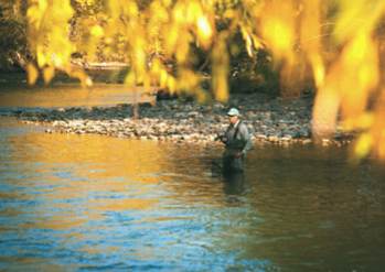
The Idaho Department
of Fish and Game
regularly stocks the river
with rainbow trout;
at right, a converted
railroad trestle over the
river.
1969 to guide the city as it developed the
trail. Adopted in 1971, the first Greenbelt
Ordinance required a minimum setback
of 70 feet for all structures and parking
areas along the greenway.
The pace in acquiring Greenbelt land
along the river corridor quickened in the
1970s as the city obtained a patchwork
of parcels through contributions or with
money from state and federal grants.
During the late 1980s and 1990s, the
Greenbelt expanded outside the city into
Ada County. The federal railbanking pro-
gram supported acquisition of the Union
Pacific right-of-way.
Today the Greenbelt extends roughly
22 miles from Lucky Peak Reservoir to
the town of Eagle. Old topographic maps
show that almost half of the corridor runs
on former railbeds. Add parts of the trail
on both sides of the river, and cyclists and
hikers have about 35 miles of off-highway
trail to enjoy—featuring more than 850
acres of parks, natural areas and scenic
cottonwood riparian stretches.
Still Growing
Expansion of the Greenbelt continues as
the Boise Parks & Recreation department
works closely with landowners and public
agencies to add more parks, recreation
facilities and trails. Plans call for the trail
eventually to extend all the way to the
Snake River.
Just last spring, the Ray Neef M.D.
River Recreation Park opened for kayak-
ers and other boaters. A dangerous irriga-
tion diversion dam was replaced here with
a Wave-Shaper structure to create waves
and play areas for whitewater kayakers.
The river park isn’t only for boaters.
The new in-river structures created more
habitat for trout, and sitting areas along
the park let you watch kayakers playing
or simply relax and read a book, with the
sounds of the river around you.
Another park, the Esther Simplot Park,
is being developed in the same area on
the north side of the river. A $1 million
gift from J.R. & Esther Simplot in 2003
allowed the Boise Parks & Recreation
department to complete the purchase of
riverfront property for the park, which
will feature 17 acres of ponds and about
nine acres of natural areas. It is expected
to be completed in a year or two.
Since the mid-1980s, the community
conversation regarding the Boise River
Greenbelt has focused on the possibil-
ity of connecting
Discovery Park, a seg-
ment of Lucky Peak
State Park, five miles
east of Boise at Lucky
Peak Reservoir, with
Eagle Island State
Park to the west.
That vision is all but
fulfilled today, with a
few miles to go.
In 1999, leaders
from 20 cities and
two counties signed the Boise River Trails
Plan, which endorses a connected system
of non-motorized paths and trails, on land
and water, on and near the Boise River
from Lucky Peak Dam to the Snake River.
With continued work and contributions,
it is hoped the Boise River Greenbelt will
keep growing and some day stretch across
63 miles of beautiful Idaho.
Pete Zimowsky has been a full-time outdoors
writer and photographer for the
Idaho Statesman
newspaper in Boise for 38 years. He also shoots
videos and writes a daily blog for the paper
at www.idahostatesman.com. His wife, Julie
Hall, also enjoys the outdoors and Boise River
Greenbelt, and helped research this story.